Maps, Annotated The World's 300 Greatest Maps Explained
-
Sprache:Englisch
-
Verlag:Dorling Kindersley
35,99 €
inkl. gesetzl. MwSt.,
Beschreibung
Produktdetails
Einband
Gebundene Ausgabe
Erscheinungsdatum
02.10.2025
Verlag
Dorling KindersleySeitenzahl
480
Maße (L/B/H)
28,9/24,3/3,7 cm
Gewicht
2394 g
Farbe
Aquamarin
Sprache
Englisch
ISBN
978-0-241-68284-5
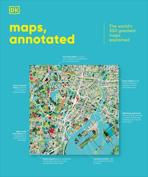
This glorious guided tour of cartographic history features more than 300 of the most famous and important maps of all time.
Immerse yourself in ancient Chinese star charts, decipher medieval Mappae Mundi, and marvel at intricate surveys of the ocean floor and the lunar surface. Discover how Polynesian navigators used sticks to chart their way across the Pacific, what a rhumb line is, and where dragons were once said to lurk.
Organized chronologically, the book includes the most celebrated examples of maps spanning more than 5,000 years, explaining everything from scales and compasses to meteorological symbols, and exploring techniques from engraving and printing to cartographic projection. Entries also place the maps in their wider cultural and historical context, providing a complete overview of the subject.
Combining stunning reproductions with precise annotation, visual analysis, and pull-out details, Maps, Annotated brings an expertly curated selection of the world's most celebrated maps right into your home, telling the fascinating stories behind each one.
Kundinnen und Kunden meinen
Verfassen Sie die erste Bewertung zu diesem Artikel
Helfen Sie anderen Kund*innen durch Ihre Meinung
Kurze Frage zu unserer Seite
Vielen Dank für Ihr Feedback
Wir nutzen Ihr Feedback, um unsere Produktseiten zu verbessern. Bitte haben Sie Verständnis, dass wir Ihnen keine Rückmeldung geben können. Falls Sie Kontakt mit uns aufnehmen möchten, können Sie sich aber gerne an unseren Kund*innenservice wenden.
zum Kundenservice